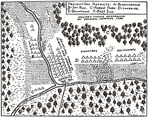
The Layout of Kekionga and the Surrounding Native Towns

The Old Apple Tree
December 15, 2021
Anthony Wayne’s Congressional Gold Medal
December 15, 2021Regarding the layout of Kekionga – prior to their destruction by Josiah Harmar’s forces in October 1790, the Indian villages and towns were located near the headwaters of the Three Rivers in present day, Fort Wayne, Indiana.”There were at that time seven towns on the three rivers in the vicinity of the confluence of the St. Joseph and St Mary’s rivers. The principal Miami village was called Omee Town, and among it’s inhabitants were a considerable number of French traders. Omee Town stood upon the east bank of the St. Joseph, or north side of the Maumee, directly opposite the mouth of the St. Mary’s; it had been burned before Colonel Hardin’s arrival. Another Miami village of thirsty houses stood on the bank of opposite Omee Town. The Delawares had three villages. Two were on the St. Mary’s about three miles from its mouth, with forty-five houses in all; the other village was on the east bank of the St. Joseph two or three miles from its mouth, with thirty-six houses. The Shawnee had two villages about three miles down the Maumee. Chillicothe was on the north bank with fifty-eight houses, and the other village of sixteen houses was on the opposite side of the river. The army burned all the houses in the different villages and destroyed about twenty thousand bushels of corn which had been hidden by the Indians. Considerable property belonging to the French traders was also destroyed.”
Source: Supplement to the Official Account to the War Department, 1791.


